Publications

Assessing the effectiveness of artificial neural networks (ANN) and multiple linear regressions (MLR) in forcasting AQI and PM10 and evaluating health impacts through AirQ+ (case study: Tehran)
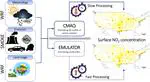
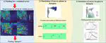
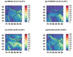
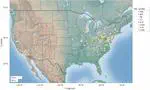
This study incorporated weather, traffic, green space information, and time parameters, to forcst the AQI and PM10. Traffic data plays a critical role in predicting air pollution, as it significantly influences them. Therefore, including traffic data in the ANN model is necessary and valuable. Green spaces also affect air quality, and their inclusion in neural network models can improve predictive accuracy. The key factors influencing the AQI are the two-day lag time, the proximity of a park to the AQI monitoring station, the average distance between each park and AQI monitoring stations, and the air temperature. In addition, the average distance between each park, the number of parks, seasonal variations, and the total number of vehicles are the primary determinants affecting PM10.The straightforward effective Multilayer Perceptron Artificial Neural Network (MLP-ANN) demonstrated correlation coefficients (R) of 0.82 and 0.93 when forcasting AQI and PM10, respectively. This study also used the forcasted PM10 values from the ANN model to assess the health effects of elevated air pollution. The results indicate that elevated levels of PM10 can increase the likelihood of respiratory symptoms. Among children, there is a higher prevalence of bronchitis, while among adults, the incidence of chronic bronchitis is higher. It was estimated that the attributable proportions for children and adults were 6.87% and 9.72%, respectively. These results under- score the importance of monitoring air quality and taking action to reduce pollution to safeguard public health.
Satellite-based, top-down approach for the adjustment of aerosol precursor emissions over East Asia: the TROPOspheric Monitoring Instrument (TROPOMI) NO2 product and the Geostationary Environment Monitoring Spectrometer (GEMS) aerosol optical depth (AOD) data fusion product and its proxy
This study aims to establish a top-down approach for adjusting aerosol precursor emissions over East Asia. This study involves a series of the TROPOspheric Monitoring Instrument (TROPOMI) NO2 product, the Geostationary Environment Monitoring Spectrometer (GEMS) aerosol optical depth (AOD) data fusion product and its proxy product, and chemical transport model (CTM)-based inverse modeling techniques. We begin by sequentially adjusting bottom-up estimates of nitrogen oxides (NOx) and primary particulate matter (PM) emissions, both of which significantly contribute to aerosol loadings over East Asia to reduce model biases in AOD simulations during the year 2019. While the model initially underestimates AOD by 50.73 % on average, the sequential emissions adjustments that led to overall increases in the amounts of NOx emissions by 122.79 % and of primary PM emissions by 76.68 % and 114.63 % (single- and multiple-instrument-derived emissions adjustments, respectively) reduce the extents of AOD underestimation to 33.84 % and 19.60 %, respectively. We consider the outperformance of the model using the emissions constrained by the data fusion product to be the result of the improvement in the quantity of available data. Taking advantage of the data fusion product, we perform sequential emissions adjustments during the spring of 2022, the period during which the substantial reductions in anthropogenic emissions took place accompanied by the COVID-19 pandemic lockdowns over highly industrialized and urbanized regions in China. While the model initially overestimates surface PM2.5 concentrations by 47.58 % and 20.60 % in the North China Plain (NCP) region and South Korea (hereafter referred to as Korea), the sequential emissions adjustments that led to overall decreases in NOx and primary PM emissions by 7.84 % and 9.03 %, respectively, substantially reduce the extents of PM2.5 underestimation to 19.58 % and 6.81 %, respectively. These findings indicate that the series of emissions adjustments, supported by the TROPOMI and GEMS-involved data fusion products, performed in this study are generally effective at reducing model biases in simulations of aerosol loading over East Asia; in particular, the model performance tends to improve
Large eddy simulation of sneeze plumes and particles in a poorly ventilated outdoor air condition: A case study of the University of Houston main campus
We simulated the outdoor transmission of a sneeze plume in “hot spots” or areas in which the air is not quickly ventilated. We began by simulating the airflow over buildings at the University of Houston using an OpenFOAM computational fluid dynamics solver that utilized the 2019 seasonal atmospheric velocity profile from an on-site station. Next, we calculated the length of time an existing fluid is replaced by new fresh air in the domain by defining a new variable and selecting the hot spots. Finally, we conducted a large- eddy simulation of a sneeze in outdoor conditions and then simulated a sneeze plume and particles in a hot spot. The results show that fresh incoming air takes as long as 1000 s to ventilate the hot spot area in some specific regions on campus. We also found that even the slightest upward wind causes a sneeze plume to dissipate almost instantaneously at lower elevations. However, downward wind provides a stable condition for the plume, and forward wind can carry a plume even beyond six feet, the recommended social distance for preventing infection. Additionally, the simulation of sneeze droplets shows that the majority of the particles adhered to the ground or body immediately, and airborne par- ticles can be transported more than six feet, even in a minimal amount of ambient air.
Downwind Ozone Changes of the 2019 Williams Flats Wildfire: Insights From WRF-Chem/DART Assimilation of OMI NO2, HCHO, and MODIS AOD Retrievals
This study looks at how the Williams Flats wildfire in August 2019 affected ozone and its chemistry in areas downwind of the fire. We used satellite retrievals and weather measurements to study this and found that by assimilating satellite data on nitrogen dioxide (NO2) and formaldehyde (HCHO) columns, we could make better surface ozone predictions. We also used data on aerosol optical depth (AOD) to better simulate the movement of the wildfire smoke. When we compared our predictions to measurements taken by aircraft, we found our predictions were mostly accurate. We found that areas closer to the fire had higher levels of nitrogen oxides, peroxyacetyl nitrate, nitric acid, and oxygenated volatile organic compounds, which contributed to an increase in ozone levels by 3–5 parts per billion in nearby areas and 2–3 parts per billion in areas further away. During more intense wildfire days, carbon monoxide and ozone plumes were transported over the Rocky Mountains to the east. Ozone regime indicators also showed a clear transition area downwind of the wildfire region that exacerbated the formation of ozone downwind. Our findings suggest that a combination of assimilating NO2 column, HCHO column, and AOD can enhance our understanding of wildfire-associated ozone chemistry and dynamics.
Surface ozone trends and related mortality across the climate regions of the contiguous United States during the most recent climate period, 1991–2020
In this study, we leverage multiple linear regression and quantile regression combined with a novel deep learning tool (SHapley Additive exPlanations) to isolate the impact of meteorology on surface ozone pollution and to assess the effectiveness of emission reduction measures across the Contiguous United States (US) during the latest climate period (1991–2020). The findings demonstrate that all regions except the Northern Rockies and the Southwest experienced decreasing trends in median values during the warm season, with rural stations in the Southeast and urban stations in the Northeast experiencing the greatest declines of −1.29 ± 0.07 and −0.85 ± 0.08 ppb.a−1, respectively. Similar to the original data, the median values of adjusted MDA8 (Maximum Daily 8-h Average) ozone show negative trends in all regions except for Southwest urban stations, with the highest recorded in rural stations of the Southeast (−1.13 ± 0.05 ppb.a−1) and urban stations of the Northeast (−0.79 ± 0.06 ppb.a−1). In addition, the 95th percentile values of original and adjusted MDA8 ozone decreased in all regions in which Northeast urban stations had the greatest reduction (original: 3.53 ± 0.29 ppb.a−1, adjusted: 2.96 ± 0.27 ppb.a−1). Our results suggest that meteorological inter-annual variability reduces the ozone burden during the warm season in the eastern US and southern California; at the same time, it contributes to increased ozone pollution in the central US, Southwest, and northern California, indicating that efforts to reduce air pollution may be hindered by climate change. Our analysis of the impact of short-term exposure to ozone on health shows that the South was the most positively impacted by emission control policies implemented after 2000, and the Northeast had the highest number of prevented deaths (30.45 deaths prevented/million people) resulting from respiratory diseases. The results of this study should benefit air quality managers and policymakers, particularly in their efforts to update ozone mitigation strategies.